

FAQs about DFR
While law enforcement and other first responder agencies are increasingly familiar with the term “Drone as First Responder” (DFR), many have questions about the details – from the specifics of what it is and how to implement a DFR program to the broader “When will DFR be available?” Check these FAQs to gain a better understanding of what’s possible and how to go about making DFR a reality for your agency.
FAQs about DFR
What is DFR?
Drone as First Responder, abbreviated DFR, is a program in law enforcement where a drone provides visibility on a scene, many times as the first ‘responder’ to arrive. Drones may be deployed for this purpose in a number of ways.
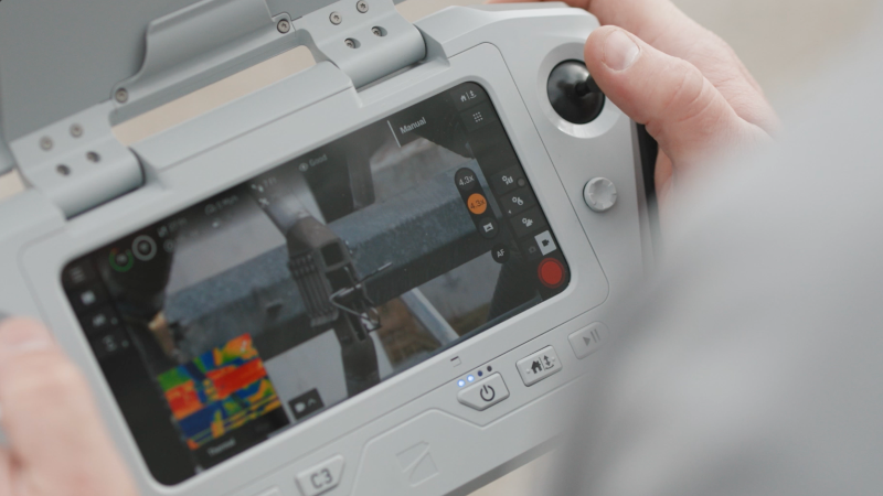
In Patrol-Led DFR drones are kept in the trunks of patrol cars, ready for deployment near the site of an incident. A responding officer can activate the drone and fly it themselves ahead of going in OR they can pass control to a remotely located pilot using the browser-based Skydio DFR Command application and keep their focus on the action on the ground.
Crew-Based DFR is a temporary step some agencies use ahead of getting their Dock-Based DFR program fully deployed. Crew-based DFR consists of setting up staffed locations (rooftop, secure area, or similar) with people serving as visual observers (while waivers are pending), handling the launch and recovery of DFR flights, and managing recharging, with remote operators handling all drone flights. This is an ideal time to continue developing system integrations and standard operating procedures before drones respond to calls for service from pre-positioned docks.
In Dock-Based DFR drones are strategically positioned in high crime hotspots or around an agency’s coverage area in protective, connected docking stations, ready to quickly fly to a scene. These setups are sometimes called drone-in-a-box. DFR drones may be activated manually by a remotely-located pilot using the browser-based DFR Command application or by an automated trigger, such as a 911 call, ShotSpotter alert or automated license plate reader (ALPR) notification. The trigger includes the location so the drone knows where to go without delay. A remote pilot can take control of an automatically activated drone at any time.
While starting a DFR program can seem daunting it doesn’t have to be. When you choose Skydio X10 drones for any program you’re already taking the first step in building a successful DFR program. They are well suited for patrol teams to keep in the trunk for overwatch any time, for SWAT teams and other specialized response, and for crime and crash scene reconstruction. Many agencies have started with specific-use drones and broadened their use to DFR, as they had the right technology and the right drone provider to help them do this.
When will DFR be available?
Leading law enforcement agencies already have active Drone as First Responder (DFR) programs TODAY. Oklahoma City Police Department, Las Vegas Metropolitan Police Department, Miami Beach Police Department, and Flagler County Sheriff’s Office among dozens of other agencies are seeing positive results from their initial implementation and are growing their DFR programs. Hundreds more agencies are in the planning stages of a DFR program.
Does the FAA allow you to fly drones without a visual observer?
Many organizations have received waivers allowing them to fly beyond visual line of sight (BVLOS) without a visual observer. The Skydio Regulatory Team has deep experience working with law enforcement agencies (as well as customers in other industries) to document their programs and successfully navigate the complex FAA waiver process. The Skydio Regulatory Team explains their strategy for allowing DFR operations without visual observers in their presentations Summiting Mount Regulation for DFR Programs and Goodbye Fear: Successfully Navigating Drone Program Regulations. The team was instrumental in helping NYPD secure a revolutionary FAA approval that will transform DFR operations, as explained in this blog post and recorded webinar.
Is radar required for DFR programs?
Radar is likely not required for DFR operations at or below 200’ AGL:
- In ADS-B airspace (Mode C Veil or surface Class C airspace)
- Over populated areas, regardless of type of airspace
Skydio anticipates that radar or additional airspace awareness technology won’t be required for agencies scaling DFR programs over populated areas. Instead, agencies can rely on Skydio’s built-in airspace awareness, powered by ADS-B data via X10 or X10 Dock, following the precedent set by NYPD’s FAA approval and recent FAA statements supporting 200’ + ADS-B operations over populated areas. The FAA is beginning to issue a small number of approvals based on this approach and are developing a process to issue similar approvals at a broader scale within the coming months. Learn more about NYPD’s waiver in this blog post and recorded webinar.
For DFR operations in unpopulated areas or for agencies deploying radar technology for counter-UAS/airspace security purposes, Skydio is integrating with DedroneBeyond to deliver aircraft and drone alerts (based on sensor configuration) within Skydio DFR Command.
What types of drones are best suited for DFR?
Most importantly, when you are considering building a DFR program, you want to have a clear understanding of all that’s involved – so you don’t get sold on a drone alone (or just a piece of software), then face the challenge of figuring out how to turn that into a program. Make sure your drone vendor has the expertise to help you plan, implement, and grow a successful DFR program. See an outline of what’s needed to build a program here.
That said, you do need to start with drones that are well-suited for DFR.
Here are some important capabilities to look for in drones you’ll use for DFR:
Advanced autonomous flight
Your ideal drones will be designed with AI as an integral technology to the hardware and software to manage complex navigation decisions in real time. When you choose drones that have the skills of an expert pilot built-in, anyone can fly – locally or remotely – with confidence, as the drone automatically avoids obstacles.
You are also well set to support fully autonomous flight. This is one of the reasons why so many public safety agencies are using Skydio X10 drones with Skydio Autonomy.
Exceptional imaging – day or night
Calls don’t stop when the sun goes down, so you need to ensure you can see clearly to manage missions at all hours. The best DFR drones will include:
- High resolution visual camera to gain crisp situational awareness and ensure evidentiary value of your images.
- Telephoto visual camera to zoom in close when you need, to see what’s in a suspect’s hand or check a license plate, for example.
- Radiometric thermal camera to track suspects or find missing persons who are hidden from view or cloaked in darkness.
- A navigation system that lets you fly in low light or darkness with full obstacle avoidance either using IR illumination or visible illumination to see what you need to without relying on GPS.
Unlimited connectivity
To ensure your drones can fly where you need them, you want them to be enabled with 5G/LTE connectivity. You can pilot Skydio X10 drones from your browser or fly them completely autonomously from a Dock for X10, triggered by a 911 call, a shot detection application, or an alert from an automated license plate recognition (ALPR) system. The 5G/LTE connectivity also enables patrol officers to activate a drone at the scene and pass off control to a remote pilot.
The cellular connectivity also serves when patrol pilots a drone directly, using a controller. They can use point-to-point when in range, and make a seamless transition to cellular when not.
Are there applications for DFR beyond law enforcement?
Yes. Public Safety agencies can use DFR for search and rescue, fire watch, firefighting, and more. In some communities police and fire are working together on DFR plans, understanding that having a shared operating picture enables a more informed response.
Other communities are taking it even further, planning to use Dock-based drones to serve a broad range of Smart City needs, that may include asset and infrastructure inspection, construction monitoring, disaster response, and transportation operations, in addition to supporting public safety applications.
Private enterprises, as well as other government agencies, recognize a variety of other applications for the DFR concept including emergency response, large event security, and site security.
What capabilities are important in a drone docking station or drone-in-a-box?
At the base level, docking stations simply serve as housing and recharging stations for the drones you position around your community. But, the design of these units can have a significant impact on the speed and reliability of your response and the success of your DFR program.
Here are some important capabilities to look for in docking stations you’ll use for DFR:
Rugged reliability
The ideal Dock makes it possible for your drone to take off and land with a high degree of reliability in rain, wind, and snow, anytime - day or night. It will stand steady against the elements, serving your needs through storm after storm.
Paired with purpose-built operational software
Your best Dock choice will be integrated with software that is created specifically to support remote operations of docked drones by law enforcement agencies. For example, Skydio DFR Command works with Skydio Dock for X10, enabling your team to launch and pilot drones from the browser, as well as take control of drones launched autonomously based on triggers from third-party applications such as computer-aided dispatch (CAD) systems, shot detections software, and automated license plate recognition systems (ALPRS).
Connectivity
To ensure a reliable response, you need reliable connectivity.
Skydio Docks are paired with a Skydio Connect External Radio to give you the best connectivity between Dock and drone. When you fly beyond the range of the access point, the drone will automatically switch to a 5G/LTE connection.
The Skydio Connect External Radio is a dedicated radio unit that communicates with X10 wirelessly and can be connected to a local network, the Internet, or the X10 controller for command of the drone and data streaming. The Skydio Connect External Radio can support a variety of different antennas (omni or directional) for different environments and mission types.
These External Radios also give you flexibility in placing your Docks, as the right locations to position and secure Docks are often not necessarily the right places for optimum connectivity. You can add these radios to your Dock setup, positioning each one in the best possible location to deliver wireless coverage to your operational area, up to 300’ away from the Dock.
Fast response
When a call comes seconds matter – so you want to ensure your drones can get out of the Dock and onto the scene fast. Skydio Dock for X10 uses an automated pre-flight sequence to get your drone airborne in 20 seconds.
Beyond Visual Line of Sight (BVLOS) readiness
For remote flight (autonomous or piloted) you must adhere to FAA regulations and secure appropriate waivers. Skydio Dock is designed to help you operate in compliance with waiver requirements, with features including:
- An Automatic Dependent Surveillance - Broadcast (ADS-B) receiver for airspace awareness
- Integrated cameras and weather sensors to support drone preflight
- Automatic contingency behaviors to respond to off-nominal situations, such as pre-programmed emergency landing zones.
- Remote ID for pilots
Additionally, the Skydio Regulatory Team has deep experience working with law enforcement agencies to document their programs and navigate the complex FAA waiver process to secure those waivers.
How many Docks do I need? Where should I position them?
There is no one-size-fits-all formula for mapping your setup; however, the Skydio team has deep expertise to help you develop a strategy and plan that will work for your community. We’ll look at your goals, your data (including the size of your force, your area of coverage, population distribution, historical call data, hotspots, potential locations, budgetary considerations, etc.), as well as airspace considerations that may govern where you fly, and share our best practices and recommendations. One thing that is certain is that DFR is not purely about geographic coverage.
What kind of software do you need for a DFR program?
As DFR is in its early stages, many point providers offer applications to address one or two specific needs related to DFR — but that leaves you with a substantial IT project to bring the various pieces together.
That’s why Skydio introduced DFR Command, the world’s first purpose-built Drone as First Responder software. This cloud-based application will provide everything you need to keep your drone fleet in a ready state, respond to calls for service, and resolve incidents with documentation and data securely moving to the right places.
See DFR Command in action with Dock for X10.
DFR Command will take full advantage of the flight capabilities that are only possible with Skydio X10 drones using AI as an integral technology to manage complex navigation decisions in real time, providing you with the capabilities to:
Automatically and manually fly drones remotely
Automate dispatch with integration to computer-aided dispatch (CAD) systems, shot detections software, and automated license plate recognition (ALPR) systems and other applications. Take remote control of a drone in flight from your browser.
- Initiate flight and pilot a dock-based drone from a browser, launching within 15 seconds with a click on “Fly now” or “Fly to point.”
- Take remote control of a drone activated by a patrol officer to pilot from a browser, allowing patrol to focus on the action on the ground.
Take advantage of enhanced flight controls for better situational awareness
- Customize Fly-to-Point using inputs such as GPS coordinates, CAD integrations, and selecting a point on a map to optimize your route for more complete situational awareness.
- Take a look around while the drone is enroute, with the pilot using Free Look to pan the area while the drone self-navigates to the incident site. This is an optional capability ideally suited for situational awareness or finding subjects in a general area where specific locations are unknown.
- Add AR overlays to show a map view, custom waypoints, teammates, and other information superimposed on the flight screen, so you have more complete information without swiveling between multiple screens.
- Control your speaker/mic, spotlight, and other attachments.
- Define geofences, safe landing zones, keep-out areas, and label your assets by uploading map layers so you’re always flying with context.
- Operate with your choice of controls: Double Click to Fly, Pointer Lock, Game Pad, or Keyboard with shortcuts that handle drone functions as well as attachment functionality (zoom, spotlights, take photos, toggle obstacle avoidance settings, boost mode / crawl mode etc.)
Livestream video from the drone
- Share a ReadyLink with the team, so everyone who needs it can quickly tune in via Skydio Live Stream, Fusus by Axon, Axon Air, Axon Respond, or other streaming apps you may use.
Manage incident resources
- Respond to any situation or call for service by giving a remote pilot control of multiple drones to ensure every angle of the situation is covered.
- Provide continuous coverage of a persistent situation with on-station relief capabilities. The pilot can seamlessly swap drones, launching a replacement drone before an active drone returns to the dock to recharge.
- Manage evolving situations with the remote pilot able to retask one or many drones at once for necessary coverage.
Provide transparency
- DFR Command includes the Skydio Transparency Dashboard, where you can provide the community with flight details you want to share, which may include flight date, start/stop time, flight telemetry (over a map view), reason for flight and case number. You always have approval over which flights to post, with the option to exclude flights from warrants or critical responses that are under investigation, for example.
Manage post-flight reporting
- Document call media and metadata for evidentiary and accountability purposes.
- Automatically upload to Axon Evidence.
- Send evidence and metadata to your digital evidence management systems.
- Post to your Skydio Transparency Dashboard for community access.
Streamline IT
- Skydio DFR Command is pre-integrated with Axon applications. Simply enter your Axon API key in your DFR Command dashboard to connect Fusus by Axon, Axon Air, Axon Respond, and Axon Evidence.
- APIs are available for additional workflow integrations, with Skydio professional services available to build if you prefer not to do-it-yourself.
- Use single sign-on (SSO) with Okta, other leading vendors.
- Get ongoing security updates.
- Trust DFR Command, now SOC II certified for enhanced security.
- Multi-display capabilities are command center ready, allowing you to set up your preferred piloting experience on a single monitor or multiple monitors.
Manage operations
- Know the state of your aircraft and docks at all times.
- Monitor fleet health via comprehensive dashboards with critical metrics.
- Get alerts and proactively manage maintenance to ensure optimal conditions, maximize uptime, and extend the lifespan of your fleet.
- Keep automated maintenance records.
How does Skydio work with Axon?
Skydio and Axon work together to create a complete DFR solution. Axon solutions are pre-integrated with Skydio law enforcement drones via DFR Command, so simply enter your Axon API key into your DFR Command dashboard to instantly share data with your Axon Air, Axon Respond, Axon Evidence, and Fusus by Axon applications. See a demo of Axon integrations, including Axon Fusus, in action here.
Skydio is developing an integration with DedroneBeyond to provide operators with alerts of detected aircraft and drones (dependent on DedroneBeyond sensor configuration) in Skydio DFR Command.
How can a DFR program help reduce use of force and officer involved shootings?
Getting drones on scene first provides responding officers and the team supporting them with better situational awareness. This time and distance enables you to get the right information needed to develop a sound tactical approach. By removing the surprise factor of walking into the unknown you calm nerves and reduce cognitive load for responding officers. Plus, you can see changes in the situation in real time as the responding officers take action. That helps you make better decisions to keep both your community and your officers safe.
What types of calls for service use DFR?
While some agencies reserve DFR deployments for high-priority incidents, drones can have a significant impact when used for a variety of other calls:
- Security and response at large-scale community events such as races, parades, festivals, and rallies.
- Overwatch on execution of search warrants.
- First look at gunshot detection to determine appropriate response.
- Accident response and resource allocation.
- Every day incident overwatch on calls for service, like in-progress burglaries, setting perimeters, and investigating suspicious activity.
- Search and rescue operations.
If my agency has access to Air Support, can we still use DFR?
Yes. Many agencies with access to Air Support supplement their patrol division with drones. Often, helicopters are unavailable – tasked with another active incident or grounded due to maintenance or weather – so you may not receive aerial assistance. And, even if available, they are typically slower to respond, more restricted in where they can fly, and more expensive to deploy, so they’re not appropriate to send for every incident. A DFR program ensures that you have aerial support, whenever and wherever you need it.
What makes Skydio the top choice for DFR?
While the Skydio X10 drone is well-designed to serve law enforcement needs, Skydio recognizes that it takes much more than a drone to build a successful DFR program. Skydio offers a complete solution, enabling law enforcement agencies to get started – and start seeing results – right away, then grow and mature their program over time.
Count on Skydio’s expertise to help you:
Be ready
- Ensure you have trained, ready staff
- Pre-position your docks to optimally serve your community and goals
- Automate dispatch with easy integration to your other systems
- Have the FAA waivers and airspace awareness you need to fly
Respond
- Get eyes on scene in less than 2 minutes for 90% of an agency's high priority calls.
- See clearly with high resolution, zoom, and thermal cameras
- Remotely pilot your drones
- Fly fully autonomously
- Stream live feed to all
- Operate through light rain and wind
- Stay steady in position through harsher weather.
Resolve
- Offload evidence
- Provide community transparency
- Simplify reporting
How do we decide if we need a DFR program?
Agencies like yours are experiencing better outcomes in their response when implementing DFR programs. If your agency’s goals include any of these metrics it’s worthwhile to explore a DFR program for your community.
- Respond faster
Drones reduce response times, often getting to the scene in less than 2 minutes. - Clear unnecessary calls for service
Agencies using DFR report being able to avoid sending ground units at least 25% of the time. - Reduce use of force
Get views of the scene from different vantage points, streamed to all responding officers and command staff to make safer tactical decisions. - Increase arrests, reduce crime, keep the community safer.
Getting eyes on the scene fast increases the chances of apprehension. - Keep officers safer.
Overwatch on every call reduces injury to officers, as well as helping to maintain officer wellness and mental health. - Build stronger community relationships.
Improved safety, greater transparency, and better outcomes help strengthen community relationships.